The World Portal


The world is the totality of entities, the whole of reality, or everything that exists. The nature of the world has been conceptualized differently in different fields. Some conceptions see the world as unique while others talk of a "plurality of worlds". Some treat the world as one simple object while others analyze the world as a complex made up of parts.
In scientific cosmology, the world or universe is commonly defined as "[t]he totality of all space and time; all that is, has been, and will be". Theories of modality talk of possible worlds as complete and consistent ways how things could have been. Phenomenology, starting from the horizon of co-given objects present in the periphery of every experience, defines the world as the biggest horizon or the "horizon of all horizons". In philosophy of mind, the world is contrasted with the mind as that which is represented by the mind. Theology conceptualizes the world in relation to God, for example, as God's creation, as identical to God or as the two being interdependent. In religions, there is a tendency to downgrade the material or sensory world in favor of a spiritual world to be sought through religious practice. A comprehensive representation of the world and our place in it, as is found in religions, is known as a worldview. Cosmogony is the field that studies the origin or creation of the world while eschatology refers to the science or doctrine of the last things or of the end of the world.
In various contexts, the term "world" takes a more restricted meaning associated, for example, with the Earth and all life on it, with humanity as a whole or with an international or intercontinental scope. In this sense, world history refers to the history of humanity as a whole and world politics is the discipline of political science studying issues that transcend nations and continents. Other examples include terms such as "world religion", "world language", "world government", "world war", "world population", "world economy", or "world championship". (Full article...)
Selected articles -
-


The map of the mouth of the River Amazon
The International Map of the World (IMW; also the Millionth Map of the World, after its scale of 1:1 000 000) was a project to create a complete map of the world according to internationally agreed standards. It was first proposed by the German geographer Albrecht Penck in 1891.
The Central Bureau of the Map of the World was established in London. After the Second World War, UNESCO took over the project. By 1953, 400 sheets had been produced. The completed sheets became outdated before the project had produced a full set of maps, and by the 1960s was being dismissed as being of no practical use. The project was no longer monitored by the 1990s. (Full article...) -

Land management has preserved the natural characteristics of Hopetoun Falls, Australia while allowing ample access for visitors.
The natural environment or natural world encompasses all living and non-living things occurring naturally, meaning in this case not artificial. The term is most often applied to Earth or some parts of Earth. This environment encompasses the interaction of all living species, climate, weather and natural resources that affect human survival and economic activity.
The concept of the natural environment can be distinguished as components:- Complete ecological units that function as natural systems without massive civilized human intervention, including all vegetation, microorganisms, soil, rocks, the atmosphere, and natural phenomena that occur within their boundaries and their nature.
- Universal natural resources and physical phenomena that lack clear-cut boundaries, such as air, water, and climate, as well as energy, radiation, electric charge, and magnetism, not originating from civilized human actions.
In contrast to the natural environment is the built environment. Built environments are where humans have fundamentally transformed landscapes such as urban settings and agricultural land conversion, the natural environment is greatly changed into a simplified human environment. Even acts which seem less extreme, such as building a mud hut or a photovoltaic system in the desert, the modified environment becomes an artificial one. Though many animals build things to provide a better environment for themselves, they are not human, hence beaver dams, and the works of mound-building termites, are thought of as natural. (Full article...) -
Human impact on the environment (or anthropogenic environmental impact) refers to changes to biophysical environments and to ecosystems, biodiversity, and natural resources caused directly or indirectly by humans. Modifying the environment to fit the needs of society (as in the built environment) is causing severe effects including global warming, environmental degradation (such as ocean acidification), mass extinction and biodiversity loss, ecological crisis, and ecological collapse. Some human activities that cause damage (either directly or indirectly) to the environment on a global scale include population growth, neoliberal economic policies and rapid economic growth, overconsumption, overexploitation, pollution, and deforestation. Some of the problems, including global warming and biodiversity loss, have been proposed as representing catastrophic risks to the survival of the human species.
The term anthropogenic designates an effect or object resulting from human activity. The term was first used in the technical sense by Russian geologist Alexey Pavlov, and it was first used in English by British ecologist Arthur Tansley in reference to human influences on climax plant communities. The atmospheric scientist Paul Crutzen introduced the term "Anthropocene" in the mid-1970s. The term is sometimes used in the context of pollution produced from human activity since the start of the Agricultural Revolution but also applies broadly to all major human impacts on the environment. Many of the actions taken by humans that contribute to a heated environment stem from the burning of fossil fuel from a variety of sources, such as: electricity, cars, planes, space heating, manufacturing, or the destruction of forests. (Full article...) -
The FIFA Women's World Cup is an international association football competition contested by the senior women's national teams of the members of Fédération Internationale de Football Association (FIFA), the sport's international governing body. The competition has been held every four years and one year after the men's FIFA World Cup since 1991, when the inaugural tournament, then called the FIFA Women's World Championship, was held in China. Under the tournament's current format, national teams vie for the remaining 31 slots in a three-year qualification phase. The host nation's team is automatically entered as the first slot. The tournament, called the World Cup Finals, is contested at venues within the host nation(s) over about one month.
The nine FIFA Women's World Cup tournaments have been won by five national teams. The United States have won four times. The other winners are Germany, with two titles, and Japan, Norway, and Spain with one title each. (Full article...) -
A map of nations which have Lèse-majesté laws as of September 2022
Freedom of speech is the concept of the inherent human right to voice one's opinion publicly without fear of censorship or punishment. "Speech" is not limited to public speaking and is generally taken to include other forms of expression. The right is preserved in the United Nations Universal Declaration of Human Rights and is granted formal recognition by the laws of most nations. Nonetheless, the degree to which the right is upheld in practice varies greatly from one nation to another. In many nations, particularly those with authoritarian forms of government, overt government censorship is enforced. Censorship has also been claimed to occur in other forms and there are different approaches to issues such as hate speech, obscenity, and defamation laws.
The following list is partially composed of the respective countries' government claims and does not fully reflect the de facto situation, however many sections of the page do contain information about the validity of the government's claims alongside said claims. (Full article...) - World history or global history as a field of historical study examines history from a global perspective. It emerged centuries ago; leading practitioners have included Voltaire (1694–1778), Hegel (1770–1831), Karl Marx (1818–1883), Oswald Spengler (1880–1936), and Arnold J. Toynbee (1889–1975). The field became much more active (in terms of university teaching, text books, scholarly journals, and academic associations) in the late 20th century.
It is not to be confused with comparative history, which, like world history, deals with the history of multiple cultures and nations, but does not do so on a global scale. World historians use a thematic approach, with two major focal points: integration (how processes of world history have drawn people of the world together) and difference (how patterns of world history reveal the diversity of the human experience). (Full article...) -

The World Bank Group (WBG) is a family of five international organizations that make leveraged loans to developing countries. It is the largest and best-known development bank in the world and an observer at the United Nations Development Group. The bank is headquartered in Washington, D.C., in the United States. It provided around $98.83 billion in loans and assistance to "developing" and transition countries in the 2021 fiscal year. The bank's stated mission is to achieve the twin goals of ending extreme poverty and building shared prosperity. Total lending as of 2015 for the last 10 years through Development Policy Financing was approximately $117 billion. Its five organizations are- the International Bank for Reconstruction and Development (IBRD),
- the International Development Association (IDA),
- the International Finance Corporation (IFC),
- the Multilateral Investment Guarantee Agency (MIGA) and
- the International Centre for Settlement of Investment Disputes (ICSID).


General images -
-

-
 A schematic view of Earth's magnetosphere with solar wind flowing from left to right (from Earth)
 -
 Japanese depiction of a Portuguese carrack. European maritime innovations led to proto-globalization.
 -
 A view of Earth with its global ocean and cloud cover, which dominate Earth's surface and hydrosphere; at Earth's polar regions, its hydrosphere forms larger areas of ice cover. (from Earth)
 -

-
 A composite image of Earth, with its different types of surface discernible: Earth's surface dominating Ocean (blue), Africa with lush (green) to dry (brown) land and Earth's polar ice in the form of Antarctic sea ice (grey) covering the Antarctic or Southern Ocean and the Antarctic ice sheet (white) covering Antarctica. (from Earth)
 -
 Artist's impression of the enormous collision that probably formed the Moon (from History of Earth)
 -

-
 An artist's impression of the Archean, the eon after Earth's formation, featuring round stromatolites, which are early oxygen-producing forms of life from billions of years ago. After the Late Heavy Bombardment, Earth's crust had cooled, its water-rich barren surface is marked by continents and volcanoes, with the Moon still orbiting Earth half as far as it is today, appearing 2.8 times larger and producing strong tides. (from Earth)
 -

-

-
 Fall of the Berlin Wall, 1989
 -
 Yggdrasil, an attempt to reconstruct the Norse world tree which connects the heavens, the world, and the underworld. (from World)
 -
 Florence, birthplace of the Italian Renaissance
 -

-
 Vitruvian Man by Leonardo da Vinci epitomizes the advances in art and science seen during the Renaissance. (from History of Earth)
 -
 Earth's western hemisphere showing topography relative to Earth's center instead of to mean sea level, as in common topographic maps (from Earth)
 -
 A map of heat flow from Earth's interior to the surface of Earth's crust, mostly along the oceanic ridges (from Earth)
 -
 Persepolis, Achaemenid Empire, 6th century BCE
 -
 The Pantheon, originally a Roman temple, now a Catholic church
 -

-
 A composite image of artificial light emissions at night on a map of Earth (from Earth)
 -
 Dinosaurs were the dominant terrestrial vertebrates throughout most of the Mesozoic (from History of Earth)
 -

-

-
 Graph showing range of estimated partial pressure of atmospheric oxygen through geologic time (from History of Earth)
 -
 Chloroplasts in the cells of a moss (from History of Earth)
 -
 Satellite time lapse imagery of Earth's rotation showing axis tilt (from Earth)
 -
 Obelisk of Axum, Ethiopia
 -
 Cross-section through a liposome (from History of Earth)
 -
 An animation of the changing density of productive vegetation on land (low in brown; heavy in dark green) and phytoplankton at the ocean surface (low in purple; high in yellow) (from Earth)
 -
 Earth's axial tilt causing different angles of seasonal illumination at different orbital positions around the Sun (from Earth)
 - Artist's impression of Earth during the later Archean, the largely cooled planetary crust and water-rich barren surface, marked by volcanoes and continents, features already round microbialites. The Moon, still orbiting Earth much closer than today and still dominating Earth's sky, produced strong tides. (from History of Earth)
-
 Empires of the world in 1898
 -
 The pale orange dot, an artist's impression of the early Earth which might have appeared orange through its hazy methane rich prebiotic second atmosphere. Earth's atmosphere at this stage was somewhat comparable to today's atmosphere of Titan. (from History of Earth)
 -

-
 Shanghai. China urbanized rapidly in the 21st century.
 -
 Trilobites first appeared during the Cambrian period and were among the most widespread and diverse groups of Paleozoic organisms. (from History of Earth)
 -
 A reconstruction of human history based on fossil data. (from History of Earth)
 -
 Ming dynasty section, Great Wall of China
 -
 Earth's night-side upper atmosphere appearing from the bottom as bands of afterglow illuminating the troposphere in orange with silhouettes of clouds, and the stratosphere in white and blue. Next the mesosphere (pink area) extends to the orange and faintly green line of the lowest airglow, at about one hundred kilometers at the edge of space and the lower edge of the thermosphere (invisible). Continuing with green and red bands of aurorae stretching over several hundred kilometers. (from Earth)
 -
 Chennakesava Temple, Belur, India
 -
 Machu Picchu, Inca Empire, Peru
 -
 Map of peopling of the world (Southern Dispersal paradigm), in thousands of years ago.
 -
 Image of the physical world, captured by the Hubble Space Telescope (from World)
 -
 A banded iron formation from the 3.15 Ga Moodies Group, Barberton Greenstone Belt, South Africa. Red layers represent the times when oxygen was available; gray layers were formed in anoxic circumstances. (from History of Earth)
 -
 A reconstruction of Pannotia (550 Ma). (from History of Earth)
 -
 A computer-generated image mapping the prevalence of artificial satellites and space debris around Earth in geosynchronous and low Earth orbit (from Earth)
 -
 Notre-Dame de Paris, France
 -
 Artist's conception of Hadean Eon Earth, when it was much hotter and inhospitable to all forms of life. (from History of Earth)
 -
 Last Moon landing: Apollo 17 (1972)
 -
 Olmec colossal head, now at the Museo de Antropología de Xalapa
 -
 First airplane, the Wright Flyer, flew on 17 December 1903.
 -
 A view of Earth with different layers of its atmosphere visible: the troposphere with its clouds casting shadows, a band of stratospheric blue sky at the horizon, and a line of green airglow of the lower thermosphere around an altitude of 100 km, at the edge of space (from Earth)
 -
 Pangaea was a supercontinent that existed from about 300 to 180 Ma. The outlines of the modern continents and other landmasses are indicated on this map. (from History of Earth)
 -
 The replicator in virtually all known life is deoxyribonucleic acid. DNA is far more complex than the original replicator and its replication systems are highly elaborate. (from History of Earth)
 -

-
 Standing Buddha from Gandhara, 2nd century CE
 -

-

-
 Taj Mahal, Mughal Empire, India
 -
 Artist's impression of a Hadean landscape with the relatively newly formed Moon still looming closely over Earth and both bodies sustaining strong volcanism. (from History of Earth)
 -

-
 Earth's history with time-spans of the eons to scale (from History of Earth)
 -

-
 Lithified stromatolites on the shores of Lake Thetis, Western Australia. Archean stromatolites are the first direct fossil traces of life on Earth. (from History of Earth)
 -

-
 Ajloun Castle, Jordan
 -
 Great Pyramids of Giza, Egypt
 -

-
 Tracy Caldwell Dyson, a NASA astronaut, observing Earth from the Cupola module at the International Space Station on 11 September 2010 (from Earth)
 -
 A pillar at Göbekli Tepe
 -
 Angkor Wat temple complex, Cambodia, early 12th century
 -
 Great Mosque of Kairouan, Tunisia, founded 670 CE
 -

-
 An artist's rendering of a protoplanetary disk (from History of Earth)
 -
 Geologic map of North America, color-coded by age. From most recent to oldest, age is indicated by yellow, green, blue, and red. The reds and pinks indicate rock from the Archean.
 -

-
 Tiktaalik, a fish with limb-like fins and a predecessor of tetrapods. Reconstruction from fossils about 375 million years old. (from History of Earth)
 -
 Change in average surface air temperature and drivers for that change. Human activity has caused increased temperatures, with natural forces adding some variability. (from Earth)
 -
 A Benin Bronze head from Nigeria
 -
 A 2012 artistic impression of the early Solar System's protoplanetary disk from which Earth and other Solar System bodies were formed (from Earth)
 -

-
 Artist's conception of Devonian flora (from History of Earth)
 -
 Battle during 1281 Mongol invasion of Japan
 -
 "Lucy", the first Australopithecus afarensis skeleton found. Lucy was only 1.06 m (3 ft 6 in) tall.
 -
 An artist's impression of ice age Earth at glacial maximum. (from History of Earth)
 -
 A 580 million year old fossil of Spriggina floundensi, an animal from the Ediacaran period. Such life forms could have been ancestors to the many new forms that originated in the Cambrian Explosion. (from History of Earth)
 - Pale orange dot, an artist's impression of Early Earth, featuring its tinted orange methane-rich early atmosphere (from Earth)
-
 Artist's rendition of an oxinated fully-frozen Snowball Earth with no remaining liquid surface water. (from History of Earth)
 -
 Earth's land use for human agriculture in 2019 (from Earth)
 -
 View of Earth from the Moon by the Lunar Reconnaissance Orbiter (from Earth)


.svg)


.jpg)


.jpg)


.jpg)


.jpeg)


Megacities of the world -

Keihanshin (京阪神, "Kyoto–Osaka–Kobe") is a metropolitan region in the Kansai region of Japan encompassing the metropolitan areas of the cities of Kyoto in Kyoto Prefecture, Osaka in Osaka Prefecture and Kobe in Hyōgo Prefecture. The entire region has a population () of 19,302,746 over an area of 13,228 km2 (5,107 sq mi). It is the second-most-populated urban region in Japan (after the Greater Tokyo area), containing approximately 15% of Japan's population.
The GDP in Osaka–Kobe is $681 billion as measured by PPP , making it one of the world's most productive regions, a match with Paris and London. MasterCard Worldwide reported that Osaka is the 19th ranking city of the world's leading global cities and has an instrumental role in driving the global economy. If Keihanshin were a country, it would be the 16th-largest economy in the world, with a GDP of nearly $953.9 billion in 2012. (Full article...)Did you know -

- ... that at the 1978 World Snooker Championship, Fred Davis reached the semi-finals at the age of 64?
- ... that a Stone Age Siberian village is the oldest known fortification in the world?
- ... that the 1917 Leeds Convention in Britain passed resolutions calling for the end of the First World War and praising the February Revolution in Russia?
- ... that after travelling around 8,300 km (5,200 mi) from Afghanistan to Ireland, Muzamil Sherzad was named a member of Ireland's squad for the 2022 ICC Under-19 Cricket World Cup?
- ... that in 1991, Juan López Mella was the first Spanish rider to achieve a podium place in the Superbike World Championship?
- ... that a minute's silence was incorporated into the opening ceremony of the 2023 FIFA Women's World Cup after a deadly shooting in a host city earlier that day?
- ... that telegraph operator Emma Hunter may have been the world's first electronic commuter?
- ... that Yusuf al-Hani was executed by the Ottoman Empire after signing a letter to François Georges-Picot that was found in the French consulate in Beirut during the First World War?
Countries of the world -

Thailand, officially the Kingdom of Thailand and historically known as Siam (the official name until 1939), is a country in Southeast Asia on the Indochinese Peninsula. With a population of almost 70 million, it spans 513,120 square kilometres (198,120 sq mi). Thailand is bordered to the northwest by Myanmar, to the northeast and east by Laos, to the southeast by Cambodia, to the south by the Gulf of Thailand and Malaysia, and to the southwest by the Andaman Sea; it also shares maritime borders with Vietnam to the southeast and Indonesia and India to the southwest. Bangkok is the state capital and largest city.
Tai peoples migrated from southwestern China to mainland Southeast Asia from the 6th to 11th centuries. Indianised kingdoms such as the Mon, Khmer Empire, and Malay states ruled the region, competing with Thai states such as the Kingdoms of Ngoenyang, Sukhothai, Lan Na, and Ayutthaya, which also rivalled each other. European contact began in 1511 with a Portuguese diplomatic mission to Ayutthaya, which became a regional power by the end of the 15th century. Ayutthaya reached its peak during the 18th century, until it was destroyed in the Burmese–Siamese War. King Taksin the Great quickly reunified the fragmented territory and established the short-lived Thonburi Kingdom (1767–1782), of which he was the only king. He was succeeded in 1782 by Buddha Yodfa Chulaloke (Rama I), the first monarch of the current Chakri dynasty. Throughout the era of Western imperialism in Asia, Siam remained the only state in the region to avoid colonization by foreign powers, although it was often forced to make territorial, trade, and legal concessions in unequal treaties. The Siamese system of government was centralised and transformed into a modern unitary absolute monarchy during the reign of Chulalongkorn (Rama V). In World War I, Siam sided with the Allies, a political decision made in order to amend the unequal treaties. Following a bloodless revolution in 1932, it became a constitutional monarchy and changed its official name to Thailand, becoming an ally of Japan in World War II. In the late 1950s, a military coup under Field Marshal Sarit Thanarat revived the monarchy's historically influential role in politics. During the Cold War, Thailand became a major ally of the United States and played an anti-communist role in the region as a member of the failed SEATO, but since 1975 it has sought to improve relations with Communist China and Thailand's neighbours. (Full article...)Related portals
Protected areas of the world -
- The country of Burundi in Africa has the following national parks and other protected areas. (Full article...)
-
This is a list of protected areas of Yukon. The Yukon, formerly called Yukon Territory and sometimes referred to as just Yukon is the smallest and westernmost of Canada's three territories. It also is the least populated province or territory in Canada, with a population of 35,874 people as of the 2016 Census. (Full article...) - This list of protected areas of Manitoba groups the protected areas of Manitoba by the agency that is responsible for their protection. (Full article...)
- Protected areas of the European Union are areas which need and/or receive special protection because of their environmental, cultural or historical value to the member states of the European Union.
(Full article...) -
- The state of Johor in Malaysia is noted for its national parks and forest reserves which preserve virgin rainforests known for its biodiversity and endangered species of animals.
Mangrove swamps and coral reefs are also protected within these parks. (Full article...) - This is a list of protected areas in Bulgaria which includes 3 national parks, 11 nature parks and 55 nature reserves. The national policy for governing and management of the protected areas is implemented by the Ministry of Environment and Water. The first nature park in Bulgaria and the Balkan Peninsula is Vitosha Nature Park, established in 1934. All of the nationally protected areas in Bulgaria are also part of the Natura 2000 network of protected natural areas in the territory of the European Union. Bulgaria has some of the largest Natura 2000 areas in the European Union covering 33.8% of its territory.
- Parks and reserves in italic letters are part of Global 200 ecoregions.
- Protected areas of Ukraine (Ukrainian: охоронні території) are special areas of Ukraine established with the goal of protecting the natural and cultural heritage of the country from excessive changes as a result of human activity. The protection of the areas is the responsibility of the government of Ukraine, specifically the Cabinet of Ministers of Ukraine.
Ukraine has several categories of protected areas of Ukraine and the protected areas include: (Full article...) - The Protected areas of Kyrgyzstan are regulated by the law on specially protected natural areas of 2 May 2011, last modified on 2 June 2018. In total, they cover 14,761.216 km2 (5,699.337 sq mi) and account for 7.38% of the country's total area (as of 2017). The first protected area in Kyrgyzstan (Issyk-Kul) was established in 1948. According to the Government Decree on Priorities of Conservation of Biological Diversity and the relevant Action Plan for 2014-2024 the target area for the protected areas in Kyrgyzstan is 10 percent of the country’s area by 2024.
The protected areas are subdivided into seven categories: (Full article...) - Protected areas of Estonia are regulated by the Nature Conservation Act (Estonian: Looduskaitseseadus), which was passed by the Estonian parliament on April 21, 2004 and entered into force May 10, 2004.
Overall Estonia has 15403 protected areas covering 21% of the country land and 18% of it marine and coastal territory, including 6 national parks: Lahemaa National Park, Karula National Park, Soomaa National Park,Vilsandi National Park, Matsalu National Park, and Alutaguse National Park (Full article...) -
This list of protected areas of Quebec includes federally, provincially and municipally administered parks and wildlife reserves in Quebec, the largest province in Canada. (Full article...) -

Part of the Brecon Beacons National Park, looking from the highest point of Pen y Fan (886 m/2907 feet) to Cribyn (795 m/2608 feet).
Protected areas of the United Kingdom are areas in the United Kingdom which need and /or receive protection because of their environmental, historical or cultural value to the nation. Methods and aims of protection vary depending on the nature and importance of the resource. Protection operates at local, regional, national and international levels, and may be backed by legislation and international treaty, or less formally by planning policy.
Within the United Kingdom, different approaches are taken to some forms of protection within the constituent countries of England, Scotland, Wales and Northern Ireland, while other forms of protection are more consistent across the UK. Protected areas can be divided according to the type of resource which each seeks to protect. Primarily, these are: scenic or landscape value; biodiversity value (species and habitats); geodiversity value (relating to geology and geomorphology); and cultural or historic value. Several types of protected areas are focused on more than one of these areas. (Full article...) -
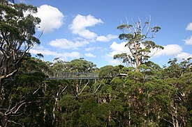
The Valley of the Giants skywalk at Walpole-Nornalup National Park
Western Australia is the second largest country subdivision in the world.
As of 2022, based on the latest Collaborative Australian Protected Areas Database report, it contains 1857 separate land-based protected areas with a total area of 76,142,710 hectares (188,152,700 acres), accounting for just over 30 percent of the state's land mass. By area, Indigenous Protected Areas account for the largest part of this, almost 67 percent while, by number, nature reserves hold the majority with two-third of all land-based protected areas being nature reserves. (Full article...) -

Grand Canyon of Yellowstone
The protected areas of the United States are managed by an array of different federal, state, tribal and local level authorities and receive widely varying levels of protection. Some areas are managed as wilderness, while others are operated with acceptable commercial exploitation. , the 42,826 protected areas covered 1,235,486 km2 (477,024 sq mi), or 13 percent of the land area of the United States. This is also one-tenth of the protected land area of the world. The U.S. also had a total of 871 National Marine Protected Areas, covering an additional 1,240,000 sq mi (3,200,000 km2), or 26 percent of the total marine area of the United States. (Full article...) -

A view at Kintrishi National Park
The South Caucasian nation of Georgia is home to several protected areas, which receive protection because of their environmental, cultural or similar value. The oldest of these – now known as the Lagodekhi Protected Areas – dates back to 1912, when Georgia was part of the Russian Empire.
The total area of Georgia's protected terrestrial territories is 6,501 km2 (2,510 sq mi), which amounts to approximately 9.29% of the country's territory. In addition 153 km2 (59 sq mi) of marine area protected, or 0.67% of the country's territorial waters. There are a total of 89 protected areas, including 14 Strict Nature Reserves, 12 National Parks, 20 Managed Nature Reserves, 40 Natural Monuments, 2 Ramsar sites and 1 Protected Landscape. Strict nature reserves comprise 140,672 ha, while national parks cover 276,724 ha. The total number of visitors to Georgia's protected areas was just under 1.2 million in 2019. (Full article...)


Selected world maps
-
 Index map from the International Map of the World (1:1,000,000 scale)
 -
 United Nations Human Development Index map by country (2016)
 -
 The world map by Gerardus Mercator (1569), the first map in the well-known Mercator projection
 -
 Only a few of the largest large igneous provinces appear (coloured dark purple) on this geological map, which depicts crustal geologic provinces as seen in seismic refraction data
 -
 Time zones of the world
 -
 The Goode homolosine projection is a pseudocylindrical, equal-area, composite map projection used for world maps.
 -
 Mollweide projection of the world
 -
 A plate tectonics map with volcano locations indicated with red circles
 -
 1516 map of the world by Martin Waldseemüller


World records
- List of Olympic records in athletics
- List of world records in athletics
- List of junior world records in athletics
- List of world records in masters athletics
- List of world youth bests in athletics
- List of IPC world records in athletics
- List of world records in canoeing
- List of world records in chess
- List of cycling records
- List of world records in track cycling
- List of world records in finswimming
- List of world records in juggling
- List of world records in rowing
- List of world records in speed skating
- List of world records in swimming
- List of IPC world records in swimming
- List of world records in Olympic weightlifting
Topics

Continents of Earth | ||||||||
|---|---|---|---|---|---|---|---|---|
| ||||||||
| ||||||||
| ||||||||


| Cenozoic Era (present–66.0 Ma) |
| ||||||||||||
|---|---|---|---|---|---|---|---|---|---|---|---|---|---|
| Mesozoic Era (66.0–252 Ma) |
| ||||||||||||
| Paleozoic Era (252–539 Ma) |
| ||||||||||||
| Proterozoic Eon (539 Ma–2.5 Ga) |
| ||||||||||||
| Archean Eon (2.5–4 Ga) | |||||||||||||
| Hadean Eon (4–4.6 Ga) | |||||||||||||
ka = kiloannum (thousands years ago); Ma = megaannum (millions years ago); Ga = gigaannum (billions years ago). See also: Geologic time scale • | |||||||||||||
| Locations | ||
|---|---|---|
| Related | ||

| |||||||||||||||||||
| |||||||||||||||||||
| |||||||||||||||||||

Economic classification of countries | |||||
|---|---|---|---|---|---|
| Three-World Model | |||||
| Gross domestic product (GDP) |
| ||||
| Gross national income (GNI) | |||||
| Wages | |||||
| Wealth | |||||
| Other national accounts | |||||
| Human development | |||||
| Digital divide | |||||
| Net international investment position (NIIP) | |||||
| Technological |
| ||||
|---|---|---|---|---|---|
| Sociological | |||||
| Ecological |
| ||||
| Biological |
| ||||
| Astronomical | |||||
| Eschatological |
| ||||
| Others |
| ||||
| Fictional | |||||
| Organizations | |||||
Categories

Wikimedia
The following Wikimedia Foundation sister projects provide more on this subject:
-
 Commons
Free media repository -
 Wikibooks
Free textbooks and manuals -
 Wikidata
Free knowledge base -
 Wikinews
Free-content news -
 Wikiquote
Collection of quotations -
 Wikisource
Free-content library -
 Wikispecies
Directory of species -
 Wikiversity
Free learning tools -
 Wikivoyage
Free travel guide -
 Wiktionary
Dictionary and thesaurus


