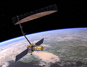
The NASA-ISRO Synthetic Aperture Radar (NISAR) mission is a joint project between NASA and ISRO to co-develop and launch a dual-frequency synthetic aperture radar on an Earth observation satellite. The satellite will be the first radar imaging satellite to use dual frequencies. It will be used for remote sensing, to observe and understand natural processes on Earth. For example, its left-facing instruments will study the Antarctic cryosphere. With a total cost estimated at US$1.5 billion, NISAR is likely to be the world's most expensive Earth-imaging satellite.
 Artist's concept of the NASA-ISRO Synthetic Aperture Radar (NISAR) satellite. | |
| Names | NASA-ISRO Synthetic Aperture Radar NISAR |
|---|---|
| Mission type | Radar imaging |
| Operator | NASA / ISRO |
| Website | nisar www |
| Mission duration | 3 years (planned) |
| Spacecraft properties | |
| Spacecraft | NISAR |
| Bus | I-3K |
| Manufacturer | NASA / ISRO |
| Launch mass | 2,800 kg (6,200 lb) |
| Power | 6,500 watts |
| Start of mission | |
| Launch date | 2024 (planned) |
| Rocket | GSLV Mk II (4 meter fairing) |
| Launch site | Satish Dhawan Space Centre |
| Contractor | ISRO |
| Orbital parameters | |
| Reference system | Geocentric orbit |
| Regime | Sun-synchronous orbit |
| Altitude | 747 km (464 mi) |
| Perigee altitude | 747 km (464 mi) |
| Apogee altitude | 747 km (464 mi) |
| Inclination | 98.5° |
| Transponders | |
| Band | S-band L-band |
| Instruments | |
| L-band (24-cm wavelength) Polarimetric Synthetic Aperture Radar S-band (12-cm wavelength) Polarimetric Synthetic Aperture Radar | |
 NISAR mission logo | |
Overview
The NASA-ISRO Synthetic Aperture Radar, or NISAR satellite, will use advanced radar imaging to map the elevation of Earth's land and ice masses four to six times a month at resolutions of 5 to 10 meters. It is designed to observe and measure some of the planet's most complex natural processes, including ecosystem disturbances, ice-sheet collapse, and natural hazards such as earthquakes, tsunamis, volcanoes and landslides.
The mission is a partnership between NASA and ISRO. Under the terms of the agreement, NASA will provide the mission's L-band synthetic aperture radar (SAR), a high-rate telecommunication subsystem for scientific data GPS receivers, a solid-state recorder, and a payload data subsystem. ISRO will provide the satellite bus, an S-band synthetic aperture radar (SAR), the launch vehicle, and associated launch services.
All data from NISAR will be freely available one to two days after observation and within hours in case of emergencies like natural disasters. Data collected from NISAR will reveal information about the evolution and state of Earth's crust, help scientists better understand our planet's natural processes and changing climate, and aid future resource and hazard management.
The satellite will be three-axis stabilized. It will use a 12 m (39 ft) deployable mesh antenna and will operate on both the L- and S- microwave bands. The aperture mesh reflector (antenna) will be supplied by Astro Aerospace, a Northrop Grumman company.
ISRO's share of the project cost is about ₹788 crore (US$99 million), and NASA's share is about US$808 million.
Launch
The satellite was to be launched from India aboard a GSLV Mark II on 30 March 2024, but has been postponed till further notice due to a needed hardware update. The orbit will be a sun-synchronous, dawn-to-dusk type. The planned mission life is three years.The satellite was fully integrated in Jaunary 2024 and was performing its final testing and analysis in preparation for launch. However, in an interview with the Times of India, Chairman of ISRO S.Somanath said that though the GSLV for NISAR will be built by March-April, the satellite is still undergoing tests and they were expecting some delay. They are now expecting to launch the satellite in the second half of the year. It was later reported that test analysis revealed that the reflector might face higher-than-expected temperatures when stowed during flight. NASA and ISRO agreed that the reflector should be returned to the manufacturer in California to apply a special coating to mitigate the risk of overheating. The special coating is designed to reflect solar radiation and thus limit temperature increases.
Gallery
- NISAR diagram
- NISAR undergoing tests
- NISAR solar array
- NISAR's DGA antenna
Payload
- L-band (1.25 GHz; 24 cm wavelength) polarimetric SAR, to be produced by NASA.
- S-band (3.20 GHz; 9.3 cm wavelength) polarimetric SAR, to be produced by ISRO.